
Features
Production
Research
Ridgetown Campus goes high-tech – very high
Up in the sky. It’s a bird! It’s a plane! No … it’s a …
March 17, 2008 By Dr. Laura Van Eerd
Up in the sky. It’s a bird! It’s a plane! No … it’s a … blimp?
Yes, that’s right, a blimp. This past summer, there was a white blimp hovering above Ridgetown Campus.
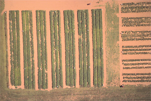 |
| Field shot from 350 ft above. The majority of the photo is the carrot research plots at Ridgetown Campus, with a grass roadway on three sides and peppers rows to the right. Notice the lighter green areas in some carrots, which corresponds to plot where no nitrogen fertilizer was applied. Contributed photos |
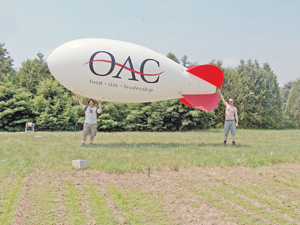 |
| The Blimp. M.Sc. graduate student Greg Young (left) and summer student Nathan Scaiff prepare the blimp for imaging. |
Up in the sky. It’s a bird! It’s a plane! No … it’s a … blimp?
Yes, that’s right, a blimp. This past summer, there was a white blimp hovering above Ridgetown Campus. And no, there wasn’t a football game or any other sporting event taking place. Instead, University of Guelph graduate student Greg Young was using the blimp to take pictures – digital images to be precise.
At 21 feet long by seven feet high, the blimp was much smaller than Goodyear’s version. Instead of carrying people, the oblong balloon-like object had two high-resolution digital cameras mounted underneath. Under the guidance of Professor Laura Van Eerd from Ridgetown Campus and Prof. Richard Heck from Guelph’s main campus, Young was taking images of vegetable crops in order to understand how plant responses relate to soil conditions.
Dr. Van Eerd’s research program focuses on nitrogen use efficiency in vegetable crops. Throughout the season, Young imaged Dr. Van Eerd’s carrot, pepper, cucumber and squash plots at Ridgetown.
“The plots have different rates of nitrogen, from 0 to 200 lb N/acre as well as split nitrogen applications and UMAXX, a product that slows the conversion of urea to nitrate, the form of nitrogen that plants use,” explains Dr. Van Eerd.
Young and Dr. Heck hope these images will be able to recognize when plants are stressed before classic nitrogen deficiency symptoms appear in the field.
This research represents the collaboration that takes place between the University of Guelph’s Ridgetown and main campuses. Young lives and takes classes at the main campus while all of his fieldwork at is at the Ridgetown Campus.
Besides Young, “Team Blimp” consisted of Nathan Scaiff, a summer student, and PhD student Aiman Soliman. The team got along really well and joked a lot together, which made repetitive data collection seem to go much quicker.
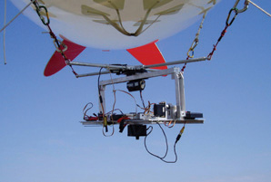 |
| Camera mount. Close-up of the cameras mounted underneath the blimp. Contributed photo |
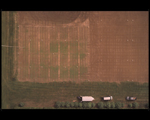 |
| Way, way up. The blimp used for research work at Ridgetown College can fly at an altitude of 300 to 500 feet above the ground. Compared to satellites, which are about 20,000 km above the field, the images from the blimp cameras have much better resolution. Therefore, detailed information on nitrogen and water stress in the plant can be characterized. And by imaging throughout the growing season, a series of snapshots is possible. Contributed photo |
The cameras took pictures by remote control, but the blimp itself was held by a rope and moved by foot power. Filled with helium, the blimp was controlled by Scaiff, who would walk across the fields to get the blimp and cameras in position to take the perfect image. Perhaps even more important, his other responsibility was to make sure the blimp didn’t escape and sail across the countryside. Hence, the blimp was tethered to Scaiff’s belt at all times.
With a very long and strong rope, the blimp flew at an altitude of 300 to 500 feet above the ground. Compared to satellites, which are about 20,000 km above the field, the images from the blimp cameras have much better resolution. Therefore, detailed information on nitrogen and water stress in the plant can be characterized. And by imaging throughout the growing season, a series of snapshots were possible.
The use of a blimp for this type of field research has several advantages over other methods of collecting soil information. Traditionally, soil samples are collected and sent to the laboratory for analysis. These samples provide valuable information on nutrient and other characteristics of the soil, such as percentage of organic matter, soil texture, and pH. Unfortunately, it is expensive and labour intensive to collect enough samples to provide widespread coverage of a field.
The blimp also has advantages over aerial photography. While aerial images provide the picture quality needed and can cover a large area, it is expensive to hire a plane, not to mention pay for fuel. Once the initial investment of the blimp was made, the only expense was the helium to float it, which was less than $300/day. The blimp is also easy to set up and can stay aloft for most of the day, providing a series of images.
But the blimp does have its limitations. Weather was a major limiting factor. A slight breeze – any more than six miles per hour – prevented the blimp from flying.
“If the winds are too strong, there is a risk that the blimp could be blown to the ground,” says Dr. Heck. There is also the threat of thunderstorms and, unlike Benjamin Franklin, Scaiff did not want to discover electricity first hand.
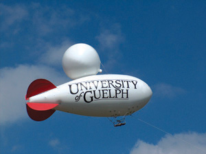 |
| The blimp. Notice the camera mount, the rope tether (to the bottom right corner) and the balloon used to provide added lift. |
Young received his bachelor’s degree in Environmental Sciences,
with a major in Natural Resources Management. He chose agricultural-
environmental field research because he enjoys the outdoors and wanted to make a positive impact. For his graduate studies, the applied aspect of this research project appealed to him.
“It is easier if I know that what I am doing might actually be useful to somebody,” he says. The research project also provides a balance between technology, environmental management and agriculture. Despite the typical technical difficulties with the camera and windy weather, Young describes the first field season as “a mix of excitement and stress.”
The blimp was also useful outside of daylight hours. Soliman used it for night imaging of the research plots, as well. The night imaging is similar to the heat seeking goggles that undercover police agents use in the movies – the ones used at night that make warm objects (such as the bad guy) appear red. Interestingly, plants under stress also image red. This is another technique to relate plant growth and stress with soil characteristics.
With more accurate information on crop and soil status, growers can adopt best management practices customized to their fields. In the future, this technology may be used by crop consultants as a decision-making tool to identify plant stress before there is a yield penalty. By predicting nitrogen and water demand, the grower can adjust fertilizer applications and irrigation, and may be most useful in fields where the fertilizer is delivered through drip irrigation.
This research project, sponsored by the Ontario Ministry of Agriculture, Food and Rural Affairs, Ontario Processing Growers Association, Canada Foundation for Innovation, and the Ontario Innovation Trust, will continue in 2007, so keep your eye on the sky in Ridgetown.
Dr. Laura Van Eerd is an assistant professor in the Department of Land Resource Science with the University of Guelph. She is based at the Ridgetown College campus.
Print this page