Features
Production
Research
Buy-and-fly orchard management using unmanned aircraft
December 12, 2017 By Penn State University
 Penn State University
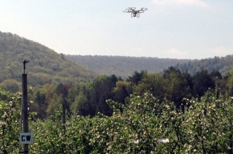
December 12, 2017, State College, PA – Unmanned aircraft (UA) – commonly called drones – are a new technology that can quickly collect, quantify, and record a variety of important data about orchards that many growers inherently measure by eye.
Simple examples include location of nonproductive trees, quantity of blossoms in the spring, stress on trees in the summer, and crop load in the fall. To this end, the State Horticultural Association of Pennsylvania (SHAP) is supporting an initiative by Joe Sommer and Rob Crassweller at Penn State University to help growers use UA for orchard management. While single images and/or videos captured during manually controlled flight can be useful, this project focused on flying autonomous missions to capture hundreds of images that can be stitched together into a much larger orthomosaic map of a block of trees or even a small orchard. For example, a DJI Phantom 4 quadcopter ($1,500) can inspect 60 acres over 15 minutes flight time at 200 feet above ground level (AGL) and reconstruct a large orthomosaic map of an orchard with one-inch per pixel resolution.
Efforts during the first year developed a user manual for mission planning and orthomosaic stitching of images as well as geo-referencing (locating latitude-longitude) for individual trees.
Growers who are interested in learning more details can visit Unmanned Aircraft for Agricultural Applications or send an email to uaaa@psu.edu.
Print this page