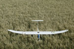
 Monitoring crop and plant growth, identifying weeds and diseases plus calculating acreage just got easier.
The CropCam is a UAV (Unmanned Aerial Vehicle) that carries a high-resolution digital camera and contains an advanced GPS guided autopilot that makes it fully autonomous. The vehicle has an eight-foot wingspan and is four feet long, weighing approximately six pounds depending on the choice of camera and mount. Cruising speed is around 35 mph, with a 60 mph maximum, allowing it to fly in winds up to 20 mph. Typical flight time is 60 minutes on a full battery charge, which gives about 50 minutes of usable flight time. Typical operating altitude is 400 to 2,000 feet, with overview quality images at 2,000 feet and incredibly detailed images at 400 feet. Maximum flight range is one mile in line of sight, but it is recommended that the CropCam be programmed to stay as close to the area being imaged as possible. It can fly over 640 acres in approximately 25 minutes to provide a general overview image. To use it, you simply program in the locations where you want to acquire images, throw the CropCam into the air, and watch it as it flies to the programmed locations, acquires the images, and lands itself. The series of images are then downloaded out of the camera and stitched together into a large seamless mosaic image of the entire field. Because the CropCam is GPS guided, it can fly the same precision pattern at any time in order to provide images from the same point of reference. CropCam also flies on demand, allowing for timely pictures without having to wait for a pilot or satellite imagery to become available. It provides an inexpensive and timely alternative to full-scale, piloted airplanes, and provides much higher resolution than satellite imagery.
For more information, visit www.cropcam.com or call 204-344-5617 (Manitoba).
Print this page